

In December 1796, a severe storm broke on the West Cork coast. A local commentator, the Rev. Horatio Townsend, noted the effects of this “memorable gale” in his Statistical Survey of the County of Cork, which was first published in Dublin fourteen years later in 1810.
At Courtmacsherry, famous for those of large size, there is a second sort of cockle, with a smooth shell, which lives in deeper water, and is seldom found but when thrown in by storms. In the memorable gale of December, 1796, vast heaps of these were driven on shore in a naked state, deprived of their shelly covering by the uncommon fury of the tempest.
Townsend also observed that the people of West Cork, accustomed to such stormy conditions, both prepared for and benefited from their situation. The islanders of Cape Clear, for instance, were said to ‘secure the thatch of their houses by an interwoven covering of straw ropes, the ends of which, as they hang over the leaves, are rendered steady by depending stones.’ Close to Rosscarbery, the ‘great quantities [of seaweed] driven on shore by the winter storms’ were a source of much-needed winter income for the then densely populated region.
During the winter months, they collect with unceasing diligence in all accessible places the weeds, which are torn from the rocks by the violence of the southern gales. When the storm subsides, the dissevered weeds float into the coves and strands, some of which are so abundantly provided, as to afford a very considerable profit to the proprietors of the ground.
Expédition d’Irlande
The major historical legacy of that winter storm of December 1796 was, however, the scuppering of the attempts at a French landing on the West Cork coast in support of the United Irishmen. Commonly known as l’Expédition d’Irlande, it comprised some 14,450 French soldiers, under the command of General Louis Lazare Hoche (1768-97) of the First French Republic, who mobilized at Brest, Brittany before setting sale in heavy seas – their objective: to land at Bantry Bay and assist in pushing the British out of Ireland.
The context of this event is important to note. The French Revolution had commenced in 1789 and led to the execution of King Louis XVI in 1793. Britain, a constitutional monarchy under King George III, had dominion over the island of Ireland, which was traditionally seen as a backdoor into its nearest neighbour. The United Irishmen, under Theobald Wolfe Tone (1763-98), and the French had shared republican ideals and a common purpose, if not common motives, for this action.
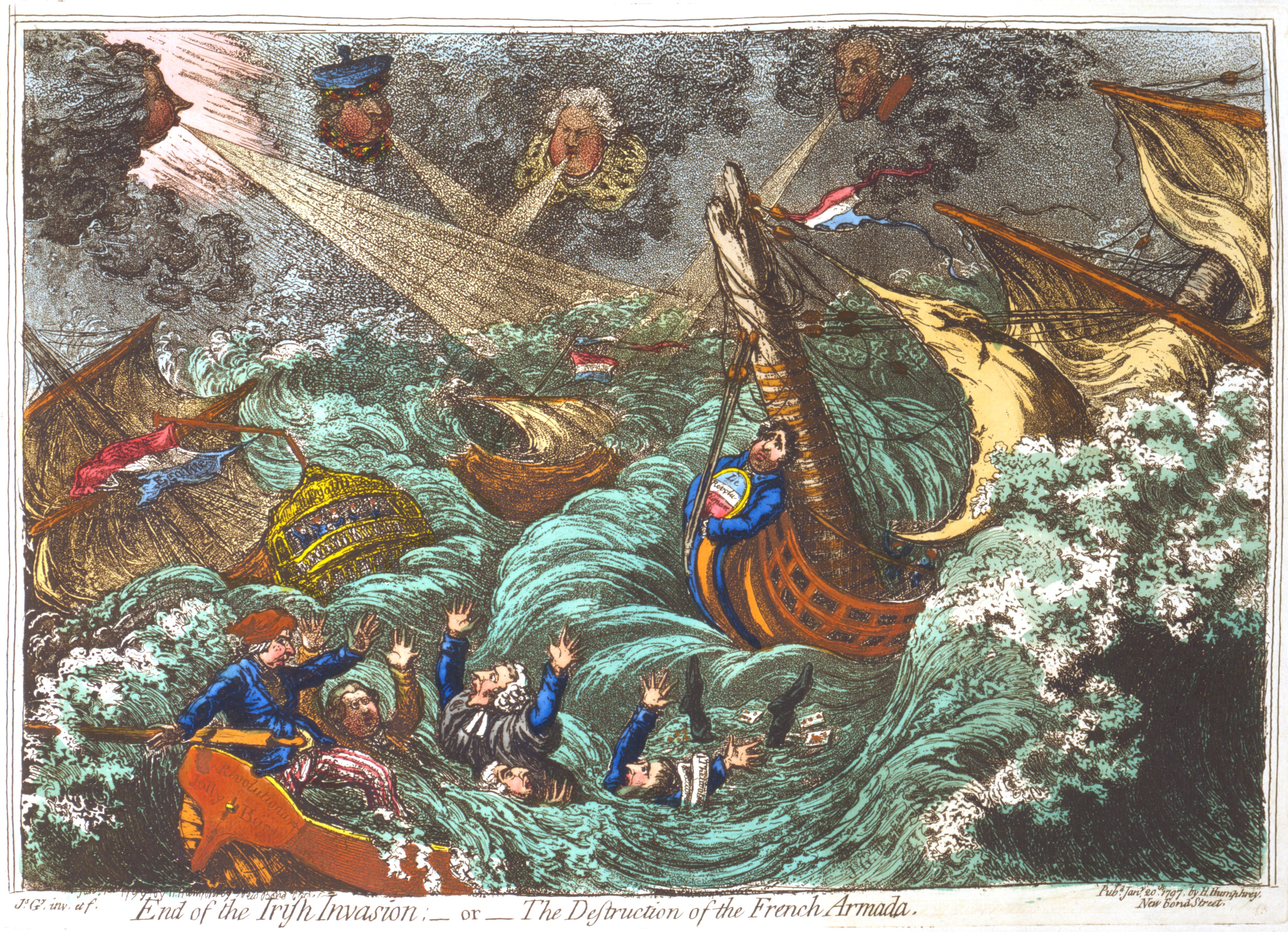
In the worst recorded storm since 1708, the French Armada was quickly scattered in the Atlantic, with only 16 of 43 vessels managing to reach Bantry Bay (Hall 147). Although the severe conditions prevented any significant British intervention, a contemporary caricature of the storm by James Gillray (c.1756-1815) erroneously attributes the failure of the so-called ‘Irish Invasion’ to the the efforts of William Windham (1750-1810), Henry Dundas (1742-1811), William Grenville (1759-1834), and British Prime Minister William Pitt (1759-1806), who can be seen in the clouds causing the rough seas. It also features the men-of-war Le Révolutionaire, L’Egalité, and The Revolutionary Jolly Boat, just three of the ’17 ships of the line; 13 frigates; 5 corvettes; 2 gun-boats; and 6 transports’ that comprised this French Armada, as noted by Mr and Mrs S. C. Hall in Ireland: Its Scenery, Character, etc. (1841). See this British Museum record for more on James Gillray’s caricature of the Expédition d’Irlande.
Coastal Defence
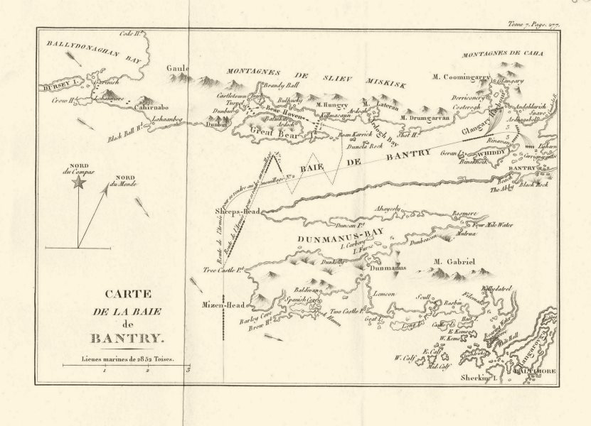
A ship’s anchor from the French expedition now resides at Wolfe Tone Square in Bantry. For some years, an exhibition (1796 Bantry French Armada) in the grounds of nearby Bantry House displayed recovered materials from another of these vessels, the frigate Surveillante, which was scuttled off Whiddy Island. While the French action was ill-timed and could not have faced worse weather conditions – they subsequently returned to France in failure and with great losses. If we return to Rev. Horatio Townsend’s writings, we can learn more about the legacy this historic event left to the region.
The second division of that great French armament, which threatened these shores in 1796, came to anchor on the north-west quarter of [Whiddy] island, and though they remained a long time in expectation of being joined by the rest, it is very remarkable that neither hostile nor curious motives induced them to set one foot upon the shore. Their boats too were often seen rowing about in the bay, probably for the purpose of taking its soundings. – The station they occupied, and the course by which they entered, are commanded by the higher parts of the island, where the principal works for the defence of the bay have, in consequence, been constructed.
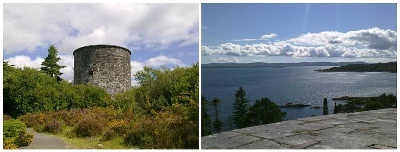
Townsend here notes the bathymetric ‘soundings’ the French made of the environs of Whiddy Island, measurements that would have helped them to determine the depth of this part of Bantry Bay and to expand their mapping knowledge of Ireland’s coastline. He also notes, however, that the threat of such actions by the French (repeated in 1798 on the north-west coast of Ireland) found a belated response in the form of coastal defences, such as redoubts and Martello Towers. Indeed, the earliest Martello Towers (cylindrical coastal defences to counter marine attacks) are thought to be those erected before 1806 at Bantry Bay, on Bere Island and Garnish Island respectively.
Only 19 of the ships that launched from Brest in 1976 made the return journey to France, due in part to damages incurred during the storm, and to the deliberate sinking of vessels at the hands of their own crew. The ‘La Surveillante’ met such an end and was scuppered on 2 January 1797 (www1) off the coast of Bantry Harbour and Whiddy Island. The ‘La Surveillante‘ was an iphigénie-class 32-gun frigate of the French Navy that most notably defeated the English frigate, the HMS Quebec, in a single-ship action in the American revolutionary war.

The ‘La Surveillante’ was rediscovered in 1979 (exactly 200 years after its decommissioning, in the aftermath of the tanker Betelgeuse’s explosion at the Whiddy Island Terminal.
Between 1998 and 2000, geophysical surveys were conducted by INFOMAR (Integrated Mapping for the Sustainable Development of Ireland’s Marine Resource) over the site of ‘La Surveillante’ to:
- accurately relocate the wreck-site
- delineate the extent of the wreck site
- map the seafloor and subsurface lithologies in the wreck-environs
- provide basemaps for more detailed diver investigations (Quinn et al., 2002)
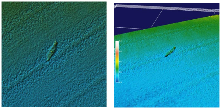
Surveys of the site revealed a NE-NW aligned wreck at a depth of 30m. Many of the ships original features were still visible during initial data collection including the galley area, bow, stern post and copper sheathing along the extent of the wreck (www1).
Copper sheathing was used in ship building during the 18th century to protect the under-water hull of a ship from the corrosive effects of salt water and from biofouling. This copper detail was previously commented upon in the Breton song ‘Chanson du Pilote’, collected by La Villemarqué in 1845 (www1; www2):
Revetus de cuivre brilliant
Qo’on dirait d’or ou d’argaent blanc
-or-
And I think it not improper
Her Hull sheathed in yellow copper
Other features identified in the wreck included canons, cannonballs and an inverted anchor which are highlighted in the below bathymetric survey.

The wreck of the ‘La Surveillante’ is a designated national monument and diving in this area is subject to licencing conditions.
Michael Waldron and Orla-Peach Power
>> The Year Without A Summer, 1816