

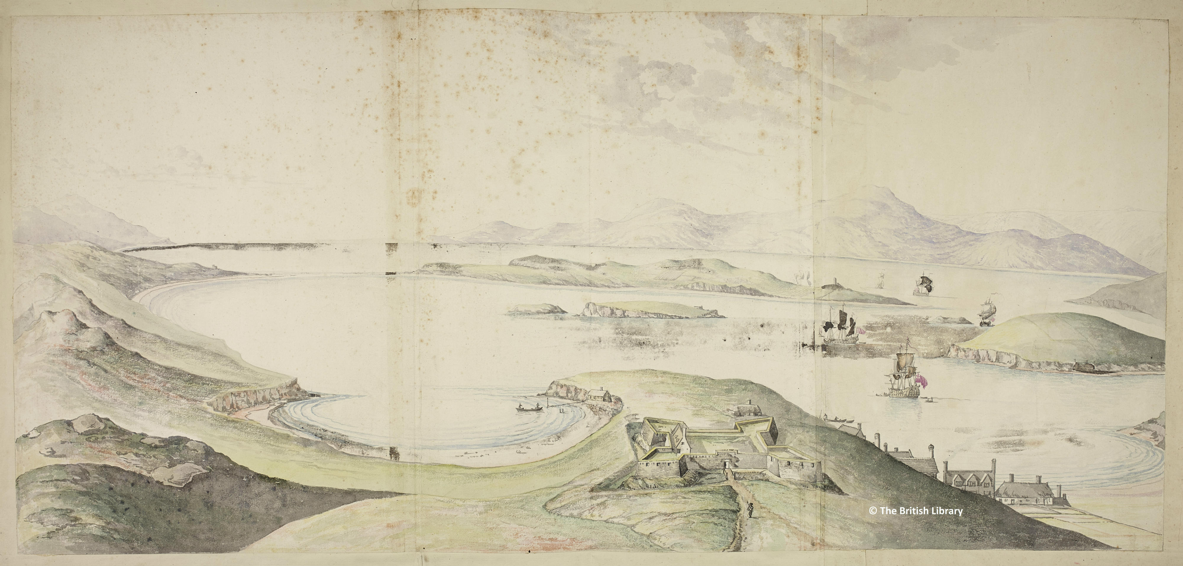
This elaborately coloured and drawn image of Bantry Bay is attributed to Thomas Phillips, a Royal Navy Engineer appointed to survey and record the fortifications and harbours of Ireland in the aftermath of the Cromwellian settlement. Phillips also made drawings of Cork Harbour and Galway. Phillips died in 1693 and this drawing is dated 1725. There are also Phillips drawings of Bantry bay in the National Library in Dublin though they do not match this one in detail or quality.
The image does not represent the current town of Bantry but rather New Town, a former Cromwellian settlement away from the older original fishing village of Ballygobbin or Bantry as it came to be known. Newtown is the townland name and the remains of the fort are barely visible, near to Newtown House. The fort and settlement are described in Charles Smith’s Antient and Present State of the County and City of Cork (1750). Smith says that New Town ‘went to decay’ and that inhabitants returned to the older settlement (the present town of Bantry, also called Ballygobbin).
The fort at Newtown would certainly have been more visible from the sea than the older fishing village, as well as more removed from the flow of river and water. The perspective offered is from New Town, affording sightlines from Bantry Bay to the Beara Peninsula across the water. The sightlines are broadly south east to north west, so that the image faces the next peninsula along rather than turning south west to the open sea.
The perspective takes in Whiddy island, which locates the image at the head of the bay, near its southern shore. An O’Sullivan Beare castle can be identified in the low lying eastern edge of the island, an area with a long strategic history: the island was fortified during the Napoleonic wars and its eastern edge became an American airstrip during the second world war.
This beautiful image might be have been intended to reassure settlers, perhaps English or Scottish artisan workers. Different types of housing (slated houses and thatched cottages) are depicted in quite a schematic way. The fishing boats are presented in some detail while the naval vessels are quite elaborately drawn. Perhaps the latter are meant to illustrate the capaciousness of the bay (‘whole navies may ride there’, ‘capable of containing all the shipping of Europe’ in various contemporary accounts) as well as to point to navigable areas.
A topographical image of this kind allows viewers to read the landscape in plan, suggesting lines of sight and points of access to the coast. The horizon seems to follow a convex form, as if drawn on a curved surface. The bay might even be under a dome in this image, as if offering a spectacle of an improved, idealised West Cork coastline.